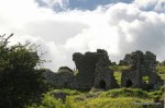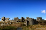

 The Rock of Dunamase, or what’s left of it, sits on top of a hill 6km from the town of Portlaoise in the Irish midlands. The limestone outcrop on which the fortress is built dominates the surrounding plains of the Great Heath. Standing over 45m high, the Rock of Dunamase has been a site of strategic importance for over 1,000 years. It must have been a very impressive spectacle in its day. Alas, these days it something that has been savaged by a Rottweiler 😦

Nobody is quite sure how long the Rock of Dunamase has been used as a fortress. Although the Greek geographer Ptolemy makes reference to a place called “Dunum” on his 2nd century map of Ireland, there is no evidence to suggest this site is what he meant. It’s a nice idea though. Archaeological digs and records from the time suggest that the rock was originally a 9th century fort called Dún Masc. Easy to see how its English name Dunamase came from. In the “Annals of the Four Masters” which chronicle Irish history, it is recorded that Dún Masc was raided by Vikings in 944AD. It would’ve been more unusual if the site hadn’t been raided by the Nordic invaders, such was their fondness for raiding and pillaging. No doubt the hapless abbot of Terryglass agreed – he happened to be here when they came a-knocking and was killed as a result of this raid.
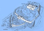
Things get a bit woolly after this. Nobody seems to know or agree on when the site became a fortress it is today. It came into the ownership of the Anglo-Normans in the 12th century and was fortified. It appears to have been owned by the wonderfully named Meiler Fitzhenry at one stage and then by William Marshall. The latter is a significant Norman figure in Irish history. It became an important centre of strategic and military importance in the region. Looking at the Office of Public Works’ recreation of the site, one can get a sense of the layout of the place.

In the 14th century, the last Anglo-Norman owner of the castle was executed by King Edward III for treason. It then came into the ownership of the Irish O’More family who didn’t handle it with care. Instead, the site was badly damaged and abandoned. Making doubly sure it wouldn’t be much use for anything, it was destroyed by Oliver Cromwell’s forces in the mid 17th century. Yet another addition to the long list of reason why he’s one of the most unpopular people in Ireland’s history.
In the late 18th century, an attempt was made to partially restore the fragmented remains. The great-grandfather of the legendary 19th-century politician Charles Stewart Parnell attempted to turn the Great Hall into a banqueting hall. Some doors and windows from other sites were added to the building and they remain to this day. It was a short-lived experiment though. Soon the castle returned to its current ruinous state, overlooking the surrounding countryside.
What’s there now?
The Rock of Dunamase is easily accessed, so no lengthy journeys along winding country boreens are needed here. There’s also plenty of parking along the road that runs past it, more than can be said for some of these places.
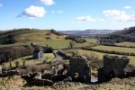
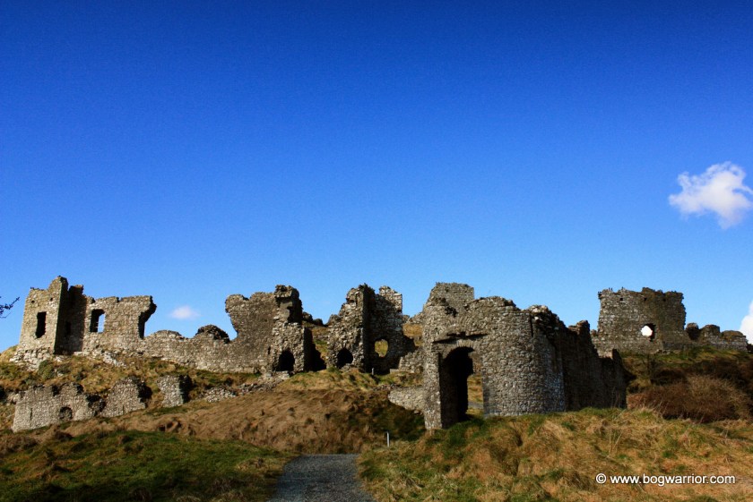
The first feature of note on the rock is the Barbican Gate which would have been the entrance to the complex. The murder hole above the entrance can still be seen and still works, should anyone have some boiling oil to hand 😉 Still to be seen along the wall attached to this gate are narrow defensive windows through which arrows could be shot at wannabe attackers.

Beyond the Barbican Gate lie the remnants of the gatehouse, a defensive curtain wall and a deep ditch. Elements of the rock itself were used as a defensive feature. Even in its current ruinous state, it’s easy to get a sense of how tricky it would have been to attack the place. Originally there would have been wooden buildings here too but they have long since vanished.
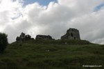
At the top of the hill are the remains of the 12th-century keep/great hall. Even though it is ruined and is surrounded by large chunks of mangled buildings, one can still get a sense of how impressive a structure it must have been. Thanks to the failed attempt to turn it into a banqueting hall, it has been altered somewhat.
The Great Hall

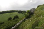
It is a pity that this place was so badly damaged all those years ago. In recent years conservation work was carried out by the Office of Public Works so it’s about as safe as these sorts of places can be. It is still well worth visiting, not just to look at the remains of the fortress itself but to admire the views from the top. The lush greenery of The Heath is very beautiful too and apparently can be seen from outer space!
Click on an image to launch the gallery